国家/地区
最后修正 2021-01-12 18:58:56
在此您可以得到世界各国和地区的法文,英文,中文名称。 这个珍贵的全人类共享的土地的集合,不仅包括世界上的独立国家, 而且也包括非联合国联合国:我联合国人民,团结起来追求更美好的世界!会员国的特殊领域。 请咨询 法语国名/地区名阴阳性详表。
21
id
国家/地区
英语国家/地区名
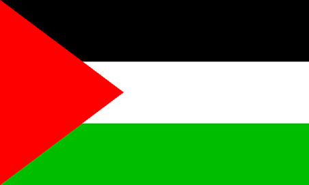
Gaza Strip
法语国家/地区名
Bande de Gaza
countryucasefr
BANDE DE GAZA
国家/地区名
西班牙语国家/地区名
Tira De Gaza
意大利语国家/地区名
Striscia Di Gaza
葡萄牙语国家/地区名
Tira De Gaza
德语国家/地区名
Streifen Gaza
countryfull
Gaza Strip
countrynm
Gaza Strip
国际编码2
PSEG
国际编码3
PSEG
countrycodeisono
275
countrycodeolympic
PLE
countrycodeirs
GZ
countrycodeirsfr
GZ
countrycodeirsmixt
GZ
♀女性
7
2
3
languagesfr
Arabe
54
currency
new shekel
currencyfr
Livre palestinienne
currencyisocode
ILS
currencyisocodefull
ILS 376
currencypxcode
ILS
currencysymbol
NIS
currencysubdivision
100 new agorot
currencyregime
m.float
currencyvalue
0.2268
nationalityfr
Gabonaise
首都
Hamala
capitalfr
Gaza
电话号码前缀
970
面积 km2
360
arealand
360
landarablerate
0.2632
coastline
40
timezonedeltabegin
2
flaglink
maplink
gaza.gif
visapassenger
-1
largestcity
Hamala
人口
1 225 911
rankincome
222
natalityrate
0.04185
mortalityrate
0.00412
mortalityrateinfantile
0.02476
growthrate
0.04
location
Middle East, bordering the Mediterranean Sea, between Egypt and Israel
terrain
flat to rolling, sand- and dune-covered coastal plain
naturalresources
arable land, natural gas
9
rgbback
16777215
todate
1
22
id
国家/地区
英语国家/地区名
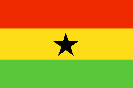
Ghana
法语国家/地区名
Ghana
countryucasefr
GHANA
国家/地区名
西班牙语国家/地区名
Ghana
意大利语国家/地区名
Il Ghana
葡萄牙语国家/地区名
Ghana
德语国家/地区名
Ghana
countrypy
jia1 na4
countrylocal
Ghana
countryfull
Ghana
countrynm
Ghana
国际编码2
GH
国际编码3
GHA
countrycodeisono
288
countrycodevehicle
GH
countrycodeolympic
GHA
countrycodeirs
GH
countrycodeirsfr
GH
countrycodeirsmixt
GH
♂男性
19
6
51
languagesfr
Anglais
41
currency
new cedi
currencyfr
cedi
currencyisocode
GHC
currencyisocodefull
GHC 288
currencypxcode
GHC
currencysymbol
¢
currencysubdivision
100 psewas
currencyregime
float
currencyvalue
0.00011
首都
Accra
capitalfr
Accra
电话号码前缀
233
面积 km2
238 538
arealand
230 940
areawater
8 520
landarablerate
0.1582
landforestrate
0.278
coastline
539
summit
Afadjoto 885 m.
boundarycountries
Côte d'Ivoire, Togo, Burkina Faso.
flaglink
maplink
ghcolor.gif
outlinemaplink
ghout.gif
visapassenger
-1
maincities
Kumasi, Tamale, Tema, Secondi-Takoradi, Cape Coast, Koforidua, Sunyani, Ho.
largestcity
Accra
largestcitypopulation
1 673 000
rankpopulation
48
人口
20 669 000
rankgdp
100
gdp
7624000000
rankgdpppp
70
gdpppp
46253000000
rankgni
107
gni
6548000000
rankincomeorigin
181
rankincome
195
income
320
rankincomeppp
155
incomeppp
2190
lifeexpectation
56.53
alphabetizationrate
0.603
natalityrate
0.02584
mortalityrate
0.01053
mortalityrateinfantile
0.05302
hdi
0.548
nationalevent
Independence Day
nationaleventfr
Jour de l'Indépendance
nationalholiday
6 March (1957)
生日 年-月-日
1957-03-06 00:00:00
4
10
location
Western Africa, bordering the Gulf of Guinea, between Cote d'Ivoire and Togo
terrain
mostly low plains with dissected plateau in south-central area
naturalresources
gold, timber, industrial diamonds, bauxite, mangan
cooking
Fruits de Mer
9
网站
rgbback
16777215
todate
1
小注
Fruits de Mer
23
id
国家/地区
英语国家/地区名
Glorioso Islands
法语国家/地区名
Iles Glorieuses
countryucasefr
ILES GLORIEUSES
国家/地区名
西班牙语国家/地区名
Islas De Glorioso
意大利语国家/地区名
Isole Di Glorioso
葡萄牙语国家/地区名
Consoles De Glorioso
德语国家/地区名
Inseln Glorioso
countryfull
Glorioso Islands
countrynm
Glorioso Islands
国际编码2
REUG
国际编码3
REUG
countrycodeisono
638
countrycodeirs
GO
countrycodeirsfr
GO
countrycodeirsmixt
GO
♀女性
15
6
57
2
currencypxcode
EUR
电话号码前缀
262
面积 km2
5
arealand
5
coastline
35.2
timezonedeltabegin
4
flaglink
maplink
go-map.gif
visapassenger
-1
rankincome
222
location
Southern Africa, group of islands in the Indian Ocean, northwest of Madagascar
terrain
low and flat
naturalresources
guano, coconuts
cooking
Southern Africa, group of islands in the Indian Ocean, northwest of Madagascar
9
rgbback
16777215
todate
1
24
id
国家/地区
英语国家/地区名
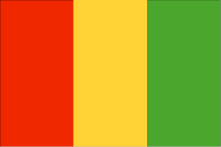
Guinea
法语国家/地区名
Guinée
countryucasefr
GUINEE
国家/地区名
西班牙语国家/地区名
Guinea
意大利语国家/地区名
Guinea
葡萄牙语国家/地区名
Guinea
德语国家/地区名
Guine
countrypy
ji1 nei4 ya4
countrylocal
Guinee
countryfull
Guinea
countrynm
Guinea
国际编码2
GN
国际编码3
GIN
countrycodeisono
324
countrycodevehicle
RG
countrycodeolympic
GUI
countrycodeirs
GV
countrycodeirsfr
GV
countrycodeirsmixt
GV
♀女性
15
4
57
languagesfr
Français
138
currency
syli
currencyfr
franc guinéen
currencyisocode
GNS
currencyisocodefull
GNS 324
currencypxcode
GNF
currencysymbol
FG
currencysubdivision
10 francs, 1 franc = 100 centimes
currencyregime
m.float
currencyvalue
0.0003
nationalityfr
Guinéenne
首都
Conakry
capitalfr
Gonakry
电话号码前缀
224
面积 km2
245 860
arealand
245 857
landarablerate
0.036
landforestrate
0.282
coastline
320
summit
Mont Nimba 1 752 m.
boundarycountries
Guinée Bissau, Côte d'Ivoire, Sénégal, Mali, Libéria, Sierra Leone.
flaglink
maplink
gncolor.gif
outlinemaplink
gnout.gif
visapassenger
-1
maincities
Kankan, Labé, Nzerékoré.
largestcity
Conakry
largestcitypopulation
1 558 000
rankpopulation
89
人口
7 909 000
rankgdp
129
gdp
3630000000
rankgdpppp
105
gdpppp
16582000000
rankgni
138
gni
3384000000
rankincomeorigin
171
rankincome
185
income
430
rankincomeppp
158
incomeppp
2080
lifeexpectation
49.7
alphabetizationrate
0.4105
natalityrate
0.04226
mortalityrate
0.01553
mortalityrateinfantile
0.09182
hdi
0.425
urbanization
0.279
precipitation
3784
nationalevent
Independence Day
nationaleventfr
Jour de l'Indépendance
nationalholiday
2 October (1958)
生日 年-月-日
1958-10-02 00:00:00
5
11
location
Western Africa, bordering the North Atlantic Ocean, between Guinea-Bissau and Sierra Leone
terrain
generally flat coastal plain, hilly to mountainous interior
naturalresources
bauxite, iron ore, diamonds, gold, uranium, hydrop
9
网站
rgbback
16777215
todate
1
25
id
国家/地区
英语国家/地区名
Guinea-Bissau
法语国家/地区名
Guinée-Bissau
countryucasefr
GUINEE-BISSAU
国家/地区名
西班牙语国家/地区名
Guinea-Bissau
意大利语国家/地区名
La Guinea-Bissau
葡萄牙语国家/地区名
Guiné-Bissau
德语国家/地区名
Guinea-Bissau
countryfull
Guinea-Bissau
countrynm
Guinea-Bissau
国际编码2
GW
国际编码3
GNB
countrycodeisono
624
countrycodeolympic
GBS
countrycodeirs
PU
countrycodeirsfr
PU
countrycodeirsmixt
PU
♀女性
15
6
114
languagesfr
Portugais
139
currency
franc
currencyfr
peso
currencyisocode
XOF
currencyisocodefull
XOF 952
currencypxcode
XOF
currencysymbol
CFAF
currencysubdivision
100 centimes [*]
currencyregime
Euro (655.957)
currencyvalue
0.00186
nationalityfr
Guinéenne
首都
Bissau
capitalfr
Bissau
电话号码前缀
245
面积 km2
36 120
arealand
28 000
areawater
8 120
landarablerate
0.1067
landforestrate
0.605
coastline
350
summit
300 m.
boundarycountries
Sénégal, Guinée.
flaglink
maplink
gwcolor.gif
outlinemaplink
gwout.gif
visapassenger
-1
maincities
Bafatá, Gabu, Mansôa, Catió, Canchungo, Farim.
largestcity
Bissau
largestcitypopulation
233 000
rankpopulation
145
人口
1 489 000
rankgdp
180
gdp
239000000
rankgdpppp
155
gdpppp
1058000000
rankgni
203
gni
202000000
rankincomeorigin
202
rankincome
217
income
140
rankincomeppp
202
incomeppp
680
lifeexpectation
46.98
alphabetizationrate
0.4145
natalityrate
0.03803
mortalityrate
0.01657
mortalityrateinfantile
0.10872
hdi
0.373
urbanization
0.323
nationalevent
Independence Day
nationaleventfr
Jour de l'Indépendance
nationalholiday
24 September (1973)
生日 年-月-日
1973-09-24 00:00:00
10
2
location
Western Africa, bordering the North Atlantic Ocean, between Guinea and Senegal
terrain
mostly low coastal plain rising to savanna in east
naturalresources
fish, timber, phosphates, bauxite, unexploited dep
9
网站
rgbback
16777215
todate
1
26
id
国家/地区
英语国家/地区名
Israel
法语国家/地区名
Israël
countryucasefr
ISRAEL
国家/地区名
西班牙语国家/地区名
Israel
意大利语国家/地区名
L'Israele
葡萄牙语国家/地区名
Israel
德语国家/地区名
Israel
countrypy
yi3 se4 lie4
countrylocal
Yisra'el
countryfull
Israel
countrynm
Israel
国际编码2
IL
国际编码3
ISR
countrycodeisono
376
countrycodevehicle
IL
countrycodeolympic
ISR
countrycodeirs
IS
countrycodeirsfr
IS
countrycodeirsmixt
IS
countrycode
972
♂男性
18
6
79
languagesfr
Hébreu, Arabe
54
currency
new shekel
currencyfr
shekel
currencyisocode
ILS
currencyisocodefull
ILS 376
currencypxcode
ILS
currencysymbol
NIS
currencysubdivision
100 new agorot
currencyregime
m.float
currencyvalue
0.2268
nationalityfr
Israëllienne
首都
Jerusalem
capitalfr
Jérusalem
电话号码前缀
972
面积 km2
20 770
arealand
20 330
areawater
440
landarablerate
0.1702
landforestrate
0.064
coastline
273
summit
Hare Meron 1 208 m.
boundarycountries
Liban, Syrie, Jordanie, Palestine, Egypte
timezonedeltabegin
2
flaglink
maplink
ilcolor.gif
outlinemaplink
ilout.out
visapassenger
-1
maincities
Tel-Aviv, Haïfa, Holon, Petah Tiqwa, Ramat Gan, Beercheba, Bene Beraq.
largestcity
Jerusalem
largestcitypopulation
1 976 000
rankpopulation
96
人口
6 688 000
rankgdp
36
gdp
110227000000
rankgdpppp
51
gdpppp
133981000000
rankgni
35
gni
108581000000
rankincomeorigin
38
rankincome
33
income
16240
rankincomeppp
44
incomeppp
19440
lifeexpectation
79.17
alphabetizationrate
0.9515
natalityrate
0.01845
mortalityrate
0.00619
mortalityrateinfantile
0.00721
hdi
0.905
urbanization
0.918
nationalevent
Independence Day
nationaleventfr
Jour de l'Indépendance
nationalholiday
14 May (1948)
生日 年-月-日
1948-05-14 00:00:00
5
1
location
Middle East, bordering the Mediterranean Sea, between Egypt and Lebanon
terrain
Negev desert in the south; low coastal plain; central mountains; Jordan Rift Valley
naturalresources
timber, potash, copper ore, natural gas, phosphate
cooking
Culture des Fruits Exotiques.
8
网站
rgbback
16777215
todate
1
小注
Culture des Fruits Exotiques.
27
id
国家/地区
英语国家/地区名
Jordan
法语国家/地区名
Jordanie
countryucasefr
JORDANIE
国家/地区名
西班牙语国家/地区名
Jordania
意大利语国家/地区名
Il Giordano
葡萄牙语国家/地区名
Jordão
德语国家/地区名
Jordanien
countrypy
yue1 dan4
countrylocal
Al Urdun
countryfull
Jordan
countrynm
Jordan
国际编码2
JO
国际编码3
JOR
countrycodeisono
400
countrycodevehicle
HKJ
countrycodeolympic
JOR
countrycodeirs
JO
countrycodeirsfr
JO
countrycodeirsmixt
JO
countrycode
962
♀女性
12
4
3
languagesfr
Arabe
142
currency
dinar
currencyfr
dinar jordanien
currencyisocode
JOD
currencyisocodefull
JOD 400
currencypxcode
JOD
currencysymbol
JD
currencysubdivision
1,000 fils
currencyregime
composite
currencyvalue
1.4217
nationalityfr
Jordanienne
首都
Amman
capitalfr
Amman
电话号码前缀
962
面积 km2
89 213
arealand
91 971
areawater
329
landarablerate
0.0287
landforestrate
0.01
coastline
26
summit
Jabal Ramm 1 754 m.
boundarycountries
Arabie Saoudite, Israël, Palestine, Syrie, Irak.
timezonedeltabegin
2
flaglink
maplink
jocolor.gif
outlinemaplink
joout.gif
visapassenger
-1
maincities
Zarqa, Irbid, Aqqaba, Salt, Ajlun, Jerash, Madaba, Ma'an, Kerak, Mafraq, Tafilaa.
largestcity
Amman
largestcitypopulation
1 183 000
rankpopulation
107
人口
5 308 000
rankgdp
95
gdp
9860000000
rankgdpppp
94
gdpppp
22929000000
rankgni
95
gni
9800000000
rankincomeorigin
116
rankincome
127
income
1850
rankincomeppp
129
incomeppp
4290
lifeexpectation
77.88
alphabetizationrate
0.891
natalityrate
0.02368
mortalityrate
0.00262
mortalityrateinfantile
0.01886
precipitation
271
nationalevent
Independence Day
nationaleventfr
Jour de l'Indépendance
nationalholiday
25 May (1946)
生日 年-月-日
1946-05-25 00:00:00
3
11
location
Middle East, northwest of Saudi Arabia
terrain
mostly desert plateau in east, highland area in west; Great Rift Valley separates East and West Banks of the Jordan River
naturalresources
phosphates, potash, shale oil
9
网站
rgbback
16777215
todate
1
28
id
国家/地区
英语国家/地区名
Juan de Nova Island
法语国家/地区名
Ile Juan de Nova
countryucasefr
ILE JUAN DE NOVA
国家/地区名
西班牙语国家/地区名
Juan de Nova Island
意大利语国家/地区名
Juan de Nova Island
葡萄牙语国家/地区名
Juan de Nova Console
德语国家/地区名
Juan de Nova Island
countryfull
Juan de Nova Island
countrynm
Juan de Nova Island
国际编码2
REUJ
国际编码3
REUJ
countrycodeisono
638
countrycodeirs
JU
countrycodeirsfr
JU
countrycodeirsmixt
JU
♀女性
15
6
57
2
currencypxcode
EUR
电话号码前缀
262
面积 km2
4.40
arealand
4.40
coastline
24.1
timezonedeltabegin
3
flaglink
maplink
ju-map.gif
visapassenger
-1
rankincome
222
location
Southern Africa, island in the Mozambique Channel, about one-third of the way between Madagascar and Mozambique
terrain
low and flat
naturalresources
guano deposits and other fertilizers
cooking
Southern Africa, island in the Mozambique Channel, about one-third of the way between Madagascar and Mozambique
9
rgbback
16777215
todate
1
29
id
国家/地区
英语国家/地区名
Kenya
法语国家/地区名
Kenya
countryucasefr
KENYA
国家/地区名
西班牙语国家/地区名
Kenia
意大利语国家/地区名
Il Kenia
葡萄牙语国家/地区名
Kenya
德语国家/地区名
Kenia
countrypy
ken3 ni2 ya4
countrylocal
Kenya
countryfull
Kenya
countrynm
Kenya
国际编码2
KE
国际编码3
KEN
countrycodeisono
404
countrycodevehicle
EAK
countrycodeolympic
KEN
countrycodeirs
KE
countrycodeirsfr
KE
countrycodeirsmixt
KE
countrycode
254
♂男性
15
6
151
languagesfr
Swahili, Anglais
143
currency
shilling
currencyfr
shilling du Kenya
currencyisocode
KES
currencyisocodefull
KES 404
currencypxcode
KES
currencysymbol
K Sh
currencysubdivision
100 cents
currencyregime
float
currencyvalue
0.013
nationalityfr
Kenyane
首都
Nairobi
capitalfr
Naïrobi
电话号码前缀
254
面积 km2
582 646
arealand
569 250
areawater
13 400
landarablerate
0.0703
landforestrate
0.3
coastline
536
summit
Mount Kenya 5 199 m.
boundarycountries
Ouganda, Soudan, Ethiopie, Somalie, Tanzanie.
timezonedeltabegin
3
flaglink
maplink
kecolor.gif
outlinemaplink
keout.gif
visapassenger
-1
maincities
Mombasa, Kisumi, Nakuru, Eldoret, Thika, Nyeri, Nanyuki, Kitale, Malindi, Kericho.
largestcity
Nairobi
largestcitypopulation
3 639 362
rankpopulation
34
人口
31 916 000
rankgdp
82
gdp
14376000000
rankgdpppp
81
gdpppp
33099000000
rankgni
84
gni
12788000000
rankincomeorigin
173
rankincome
187
income
400
rankincomeppp
189
incomeppp
1030
lifeexpectation
44.94
alphabetizationrate
0.8425
natalityrate
0.02782
fecondity
4
mortalityrate
0.01631
mortalityrateinfantile
0.06262
hdi
0.489
urbanization
0.925
precipitation
1063
nationalevent
Independence Day
nationaleventfr
Jour de l'Indépendance
nationalholiday
12 December (1963)
生日 年-月-日
1963-12-12 00:00:00
10
4
location
Eastern Africa, bordering the Indian Ocean, between Somalia and Tanzania
terrain
low plains rise to central highlands bisected by Great Rift Valley; fertile plateau in west
naturalresources
gold, limestone, soda ash, salt, rubies, fluorspar
9
网站
rgbback
16777215
todate
1
30
id
国家/地区
英语国家/地区名
Lesotho
法语国家/地区名
Lesotho
countryucasefr
LESOTHO
国家/地区名
西班牙语国家/地区名
Lesotho
意大利语国家/地区名
Il Lesoto
葡萄牙语国家/地区名
Lesotho
德语国家/地区名
Lesotho
countrypy
lai4 suo3 tuo1
countrylocal
Lesotho
countryfull
Lesotho
countrynm
Lesotho
国际编码2
LS
国际编码3
LSO
countrycodeisono
426
countrycodevehicle
LS
countrycodeolympic
LES
countrycodeirs
LT
countrycodeirsfr
LT
countrycodeirsmixt
LT
♂男性
12
6
192
languagesfr
Sotho, Anglais
145
currency
loti, pl., maloti
currencyfr
loti
currencyisocode
LSL
currencyisocodefull
LSL 426
currencypxcode
LSL
currencysymbol
L, pl., M
currencysubdivision
100 lisente
currencyregime
South African Rand (1.0)
currencyvalue
0.1453
首都
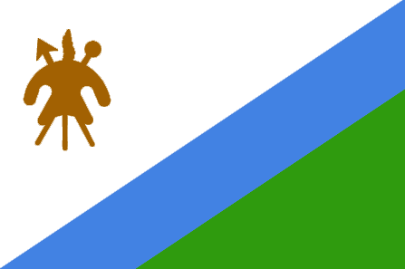
Maseru
capitalfr
Maseru
电话号码前缀
266
面积 km2
30 350
arealand
30 355
landarablerate
0.1071
landforestrate
0.005
summit
Thabana Ntlenyana 3 482 m.
boundarycountries
Afrique du Sud.
timezonedeltabegin
2
flaglink
maplink
lscolor.gif
outlinemaplink
lsout.gif
visapassenger
-1
maincities
Teyateyaneng, Leribe, Mafeteng.
largestcity
Maseru
largestcitypopulation
297 000
rankpopulation
143
人口
1 793 000
rankgdp
153
gdp
1139000000
rankgdpppp
143
gdpppp
4591000000
rankgni
169
gni
1089000000
rankincomeorigin
156
rankincome
170
income
610
rankincomeppp
144
incomeppp
3100
lifeexpectation
36.81
alphabetizationrate
0.84
natalityrate
0.02691
mortalityrate
0.02479
mortalityrateinfantile
0.08522
hdi
0.51
nationalevent
Independence Day
nationaleventfr
Jour de l'Indépendance
nationalholiday
4 October (1966)
生日 年-月-日
1966-10-04 00:00:00
3
7
location
Southern Africa, an enclave of South Africa
terrain
mostly highland with plateaus, hills, and mountains
naturalresources
water, agricultural and grazing land, some diamond
9
网站
rgbback
16777215
todate
1
